Monday 31 January 2022

Clipston Circular walk via Sibbertoft

Flying solo today, the usual walking buddies all busy doing other things. The walk follows on from the one I did a couple of weeks ago around Naseby. That particular walk wasn't blogged as the weather was so misty.Not to worry though, I will do it again at some stage with pictures you can actually see. 

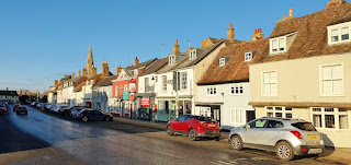
Parked up close to the village pub and near to the village Green, I take a bit of a wander into the village. As you might imagine there are many links to the Battle of Naseby. 

On the right hand side is the old Free Grammar School and Hospital. I'm heading down towards the church when I spot a group of Ramblers coming from the opposite direction. I detour into All Saints Church, which is locked but I do pick up a copy of the 'Jack Dee' autobiography from a box in the porch. Is it called a Vestry? Or is it a Vestibule? I'm not really sure at all, somebody more ecclesiastical will know I'm sure. Amazingly spell checker has not flagged up on the 'e' word. 

It is safe to venture out again as the Ramblers have reached the top of the High Street.    


All Saints Church Clipston

Re-tracing my route I pass the War Memorial and pick up the footpath on the other side of the road. The path is a narrow alley way leading to Chapel Lane. There is a lot of Goldfinch activity on the Ivy bushes nearby.    

There is a large Baptist Chapel on Chapel Lane. It's great how these things come together isn't it! Dating back to 1803 it is an impressive if somewhat spooky looking building.

The Ramblers are gathered outside too, this is going to be awkward.... I have nothing whatsoever against Ramblers let me state that here and now. I just don't like to be organised,preferring to do my own thing in my own time. I manage to get a photo and avoid getting signed up for all sorts, moving on swiftly. Heading out of the village there is a nice sign informing visitors that they have arrived in Clipston.    


Leaving the village behind I pick up a footpath on the right hand side of the road. It leads to open fields and an uphill climb, the views are superb but it is very blustery.

My progress comes to an abrupt halt ... the narrow gap through the hedgerows is pretty much a swamp. I hear voices behind , It's only the Ramblers again who have somehow caught me up. I've got to go for it now, no choice but to hang on to the edge of the hedge and navigate the least deep part of the quagmire. Showing some amazing dexterity I pull it off with minimal mud impact.Scampering off like the wily old Fox I leave the pursuers behind to work out their own way of getting through. I wounder what the collective noun for a group of Ramblers is? A 'Ramble' perhaps? or maybe a 'Rambling'? Today I'm going with an 'Annoyance'. 


Officially called Royal Observer Corps (ROC) Monitoring Posts,or under a ramshackle pile of bricks lies a Cold War nuclear bunker. A 14-foot-deep access shaft, a toilet/store and a monitoring room.The posts were constructed as a result of the Corps' nuclear reporting role and operated by volunteers during the Cold War between 1955 and 1991. I wasn't supposed to go in the field but climbed the gate for a closer look. 

Climbing back over the barbed wire fence I find a Bank Debit card on the verge. Closer inspection reveals that it is actually mine. Must have fallen out of my phone case as I climbed over. 

Back on the safety of the road I spot some clumps of Snowdrops, the first I have seen this year. It's a short bit of road walking and very pleasant. A couple of other walkers pass by coming from the other direction. There is a footpath on the right which leads to 'Marston Trussell' which I always think sound like a great place to visit. I will add it to the list! 

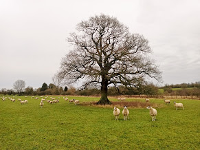
I'm looking for the 'Jurassic Way signpost which isn't far way. I take the left hand route and it is back across open fields and some very inquisitive sheep. There are a couple of stiles to overcome and then an uphill climb into the woods. 


The scenery is absolutely beautiful around here. Nice just to take a few minutes and listen to the birds. There is a lot of bird activity, I manage to see a lot of the usual suspects, along with a pair of Goldcrest's and a Great Spotted Woodpecker.

There is supposed to be a diagonal path across the next field but I can't see it . I follow the edge of the field instead around an area showing as 'The Coombes' on my map.  It looks like it was a quarry at some stage perhaps?


Funnily enough, after the long walk to the next stile the path becomes quite clear looking back.

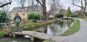
The next part of the walk is quite tricky, as once again the paths are not particularly clear. A little bit of trial and error and a slight false start but not too bad really. I manage to navigate myself back to the road via a little footbridge though. As regular readers will know I do like a footbridge. 

From the road it is just a short walk into the village of Sibbertoft.   On the right hand side is the Grade II listed St Helen's Church. There was presumably a church at Sibbertoft by 1086 as the Domesday Book has a priest living there.

It is going to be all road now all the way back to Clipston. 


There isn't a great deal of interest to report on the road journey back to the starting point. However my keen eye spots an interesting looking building on the left. It is the site of Sibbertoft Manor which is now a Nursing or Care home. The building dates back to Georgian times.

A very enjoyable walk with some great countryside. The road part at the end was a bit tough on the feet but a good 7.4 miles completed.


Tuesday 25 January 2022

Kimbolton Walk


We have headed out of County in an easterly direction for this particular walk. Kimbolton, is about 9 miles (14 km) west of Huntingdon, and 14 miles (23 km) north of Bedford. I believe it lies in the County of Cambridgeshire, although it could be Bedfordshire or even Huntingdonshire? Wherever we are the skies are a rich blue colour , the sun is out but still bitterly cold in the shade. 

We start from close to the Church Of St Andrew, said to have existed on this site long before the Norman Conquest. In 1066. 

At the east end of the north aisle there is a monument to the U.S.A.F. 379th Bombardment Group, who were stationed at Kimbolton Airfield during the Second World War from May 1943 to June 1945. 

We pass close to the famous 'Kimbolton School', but there will be more about that later. We head away from the centre in the direction of Honey Hill Wood. 


The path literally took us across the outfield of Kimbolton Cricket Club. A very nice located ground indeed.

There are lots of shooting pegs marked out for a spot of Pheasant bagging. Thankfully all is quiet today and the poor birds live to flight another day. 

We are heading towards the small village of Pertenhall, which is in Bedfordshire. The name derives from Peters Hill (allegedly) based on the Hill by St Peters Church. The church is the oldest building and dates back to Norman times.  


We have a bit of a climb heading towards 'Chapel Yard' and 'Wood End Farm'. The views looking back are quite spectacular though. Looks like we are heading back into Cambridgeshire again!


In the distance Kimbolton Castle is bathed in sunshine. It is famous as the final home of King Henry VIII's first wife, Queen Katharine of Aragon. The earliest known castle in Kimbolton, a wooden motte and bailey castle, dating from Norman times, was not on the present site. All that remains of the Norman castle is a low mound, surrounded by a ditch and covered with trees.

Catherine died at Kimbolton Castle on 7 January 1536. There were some rumours that she had been poisoned. The rumours were born after the apparent discovery during her embalming that there was a black growth on her heart that might have been caused by poisoning. Modern medical experts are in agreement that her heart's discolouration was due not to poisoning, but to Cancer, something which was not understood at the time.

Catherine was buried in Peterborough Cathedral after lying in state at Kimbolton Castle. 


It is through very muddy fields we trek, as we make our way towards Kimbolton Park. I'm regretting cleaning the boots now the day before..

It's a bit of a posh school, and I don't think they will be too happy with mud all across their entrance. And we are talking serious mud here. Since 1950, the school has occupied Kimbolton Castle and It's grounds. 

The cost to send your child to Kimbolton starts at £10,300 as an annual fee for the lower prep school and can rocket up to £28,560 per year for full boarding at the senior school. A lady pulls over in a car and asks what we know about the School?Our blank looks give us away somewhat. I don't think it's cheap was about the most help I could offer. 

Emerging from the school gates we find ourselves back on the High Street. Although one of the smallest towns in Cambridgeshire, Kimbolton was a very important market town during the medieval period.dominated at one end by the Palladian castle/mansion of the Dukes of Manchester and at the other by the spire of the 13th-c Parish Church of St Andrew. Both pictured on this very blog.

The town's wide High Street (originally the market place) boasts over 80 listed buildings. Now designated as a conservation area, it retains much of its original historical character.

We hadn't quite finished yet as there was still a climb up to and around the old airfield. Originally built in 1941 for RAF Bomber Command for use by American heavy bombers during 1942. Another muddy field and more mud for the boots! The walk complete and a nice round 9.5 miles covered.


Monday 10 January 2022

Heart of England Way (1) Bourton On The Water and Stow On The Wold


The H of E Way from Bourton
The H of E Way entire route

Today's circular route

Another year and the start of another long distance footpath. We are about to start on the 'Heart of England Way'. A walk of around 100 miles (160 km). The walk starts, or ends at Bourton on the water (Gloucs) and finishes at Cannock Chase (Staffs). As always we will be completing circular walks rather than a linear route.

The starting point today is actually the Cotswold village of Lower Swell. Perhaps that makes us a 'couple of Swells'? 

Eventually we head off in the right direction after going 180 degrees the wrong way....Almost miraculously the rain has stopped! The forecast is 86% heavy rain all day. Which indeed it has been all the way down. I'm taking no chances though , full wet weather gear is the order of the day , complete with Bushman 's hat. I look the part if nothing else , although probably won't win any prizes for style today.


It's official we are on our way and there are plenty of signs to confirm it too! In fact it seems to be the epicenter for all sorts of walks and ways as a photo will soon confirm. I quite like the look of the 'Donnington Way' though which seems to be something of a glorified pub crawl. Named after the Donnington Brewery it is a 62 mile circular route linking up 15 pub sections. What could be better?

We are heading towards 'The Slaughters', surely one of the most inappropriately named places in the UK .I believe that the name derives from the Old English 'Slough' meaning wet land. It is certainly living up to It's name today at least as the fields are soaked. 

The village is built on both banks of the River Eye.We will only pass through Lower Slaughter but the river continues to Upper Slaughter. 


This is quintessential England, a tourist mecca of course in different times. Not many people around today all things considered. In 2013, the Parish Council opposed an icebox tricycle selling ice creams seven days a week, six months of the year, arguing that the trading times were excessive. Increased footfall would prevent the grass from growing and children could climb on the trike and fall into the nearby river... I wish my grass would stop growing and isn't it part of growing up falling off bikes, and paddling in rivers. We passed the Cricket ground which made me smile, Slaughters United CC.Enough to strike fear into any would be opposition for sure.


Bourton on the Water is our next port of call. No sooner have I managed to get the tune of 'Bring your Daughter to the Slaughter(s) (Iron Maiden) than another one pops in. I now have 'Smoke on Bourton on the Water' (Deep Purple milling around). I have been here several times before and it has always been rammed with tourists. Very quiet indeed today though. 

Bourton-on-the-Water at the heart of the Cotswolds is famed for its five stone bridges. Dating from between 1654 and 1911, the bridges are constructed from local Cotswold stone and give the village its nickname of ‘Venice of the Cotswolds’.

Rising in the Cotswold Hills near Taddington the River Windrush meanders gently through. It flows for about 35m until meeting The Thames.

Leaving Bourton we pick up the Oxfordshire Way towards Wyck Rissington. Things are also getting muddier underfoot, as we embark on a time travel trail with a replica Iron Age Roundhouse. 


Owned by Gloucestershire Wildlife Trust, Greystones is home to wildflower meadows, Iron Age ramparts,  working organic farm, and an interactive Discovery Barn. As well as the a replica Iron Age roundhouse pictured above. 

Salmonsbury Camp, the site of Europe’s earliest known towns, is a scheduled monument located at Greystones. It is recognised as a good example of an Iron Age fortified enclosure and for the extensive archaeological finds collected from the site.


We are climbing slowly towards Stow On The Wold. We walk alongside the busy 'Fosse Way' before taking the 'Macmillan Way' path. There are some stunning views to our right. The light is starting to fade and there is more light rain so the photo on the left doesn't do the view justice. 

By the time we reach the old market town of Stow On the Wold it is much darker. Siting on top of an 800-foot (244 m) hill it has been the toughest part of the walk. I didn't get a decent photo at all sadly due to the light. I will post the only one taken which isn't very good....

Keeping the musical theme going John Entwistle the Bassist with The Who lived in a Victorian Manor here for 27 years from 1976. Built on a hill near to Lower Swell apparently with 55 rooms,

Known for a macabre sense of humour, Entwistle kept skeletons in the master bedroom to frighten guests.

His funeral was held at St Edwards Church Stow on 10 July 2002. 

The mansion 'Quarwood' and some of his personal effects were later sold off to meet the demands of the Inland Revenue. Rather ironically he had worked for the agency from 1962–1963 as a tax officer before being demoted to filing clerk, prior to joining the Who.


We are well on our way  towards our start point at Lower Swell and The Heart of England Way. The most widely accepted theory behind the name "Swell" is that it relates to a spring that rises in the grounds of the Abbotswood Estate to the north of the village and is an abbreviated version of "Our Lady's Well". The well can still be seen today.It is pictured left with 'Archie' 

It is now nearly dark and the legs are feeling the 12. 6 miles covered today. A good start to the new walk and the weather exceed expectations too!

Mr Punch - The Musician Leicester

I've just passed a late fitness test and have made it to 'The Musician' in Leicester. Just hoping that my knee will take the str...