Wednesday 30 December 2020

The Shakespeare's Avon Way - Welford (2)


St Mary's Church Welford


The second leg of The Shakespeare's Avon Way and we are starting from St Mary's Church in Welford.Located on the River Avon border between Leicestershire and Northamptonshire.

After 'Storm Bella' did her worst overnight it is calm and bright. We are under no illusion how boggy some of the parts are likely to be. Hopefully the floods won't be bad enough to stop the intended route?


Flooded Fields ......

We are not far out of Welford when we pick up the Grand Union Canal.  The Welford Arm is a short, 1 mile, waterway leading to the village of Welford. The canal was opened in 1814 and originally built as a navigable feeder, linking the Welford Reservoir and Sulby Reservoir to the Old Grand Union Canal. 

What is this we see? A dam seems to have been created, surely not Beavers ??  I suspect with the the high water and stormy winds the old reeds have all been dredged up over the outlet pipe.  

For this part of the walk we don't seem to be particularly close to the River Avon. Although we are passing close to the village of Stanford On Avon which is reassuring. 

It is nice to leave the sodden fields and take the road that leads to our next village Clay Coton. Either side of the road there are impressive pillars giving distances to places nearby.


Distance markers

Clay Coton

Sadly one of them seems to have lost the globe off of the pillar. Our water problems were far from over though.... The road into Clay Coton was flooded with several inches of water. No alternative but to walk through it, the result being pretty wet feet. A couple of cyclists coming the other way seemed to make much better progress than we did though. 

There are some lovely properties along the road too. The village is dominated by the former Church of St Andrew built in 1340. It fell into disuse in the 1950s and was renovated as a private house in 2000. However, the surrounding graveyard still has public access.  All of which are flooded out today.

This will be our starting point for the next leg of the journey. Hopefully it will be a bit drier. But for now we are heading away from the Shakespeare's Avon Way. More saturated fields await us.   


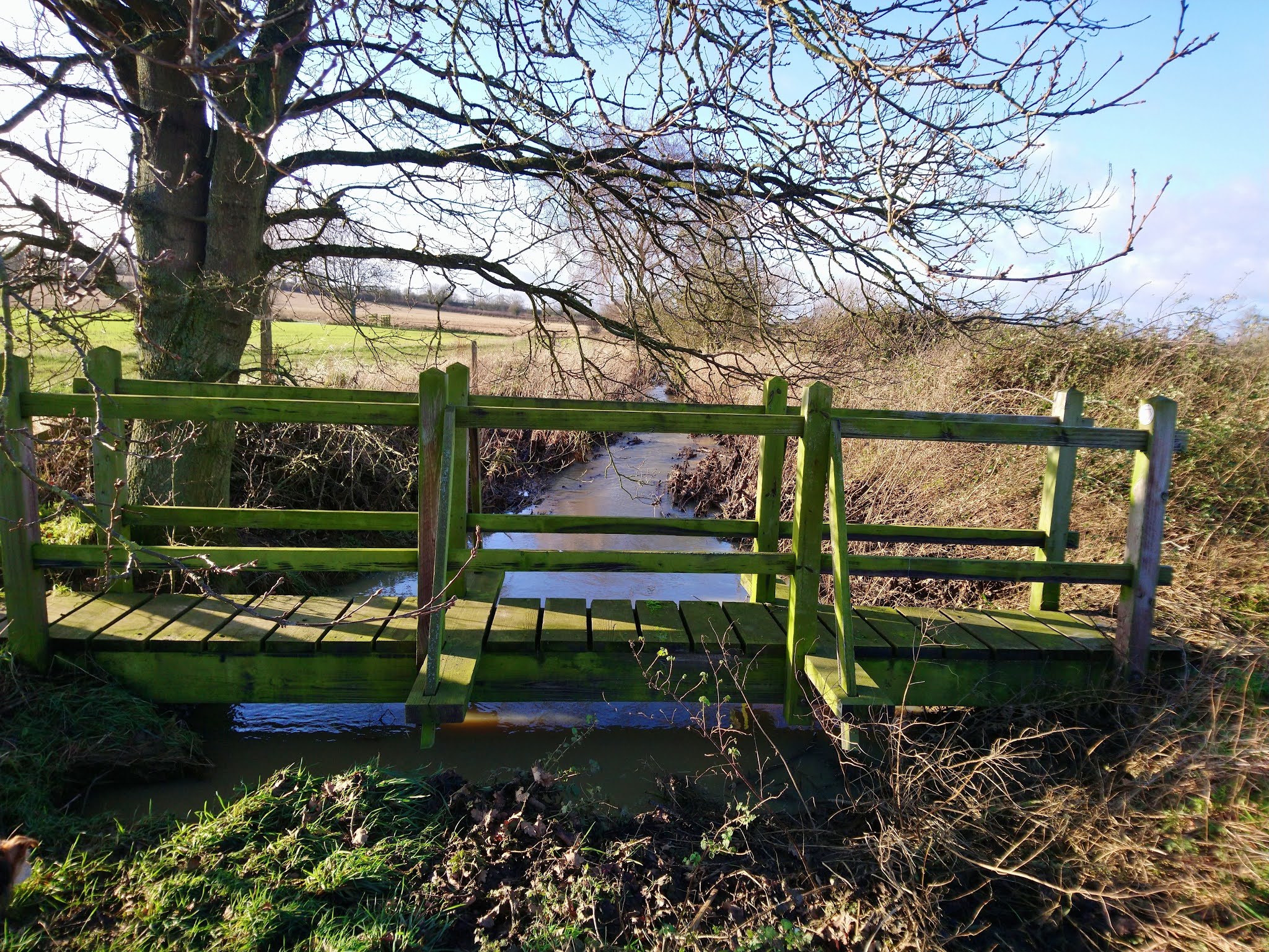
A handy bridge for crossing the swollen river.

We cross the A14 once gain and further on to Bridge 31 on the canal picking up the Jurassic Way footpath.  The path ahead is very clear and we are approaching the Hemplow Hills. 

It is a slog through the mud to reach the woodlands. It is an even harder climb when we get there as the path becomes steeper and stickier. Looking back there are fantastic views of Honey Hill and wonderful rolling countryside. 

Hemplow Hills
A Christmas Donkey

Leaving behind the Hemplow Hills it is the final part of the walk and back to the starting point at Welford. 

It is mostly by road and then through a small housing estate. Seems that a few other walkers are returning back to their cars as the light starts to fade.

It has been a great walk and quite a long one coming in just short of 10.5 miles.


Monday 28 December 2020

Cottesbrooke Christmas Walk


A beautiful crisp and sunny Christmas morning for a walk around one of the most beautiful areas in the County. Walk number 132 on the Northamptonshire Walks website is the planned route for today. There has been a sharp frost overnight on top of all the recent rainfall. Hopefully it should make some of thye mud a little easier to walk on?

Leaving the car in the middle of the village we set off passing the Grade 1 listed All Saints Church on our right hand side. It is distinguished for its architecture and the box pews and three-Decker pulpit in the nave.One of the bells, dated 1317, is reputed to be the world’s oldest bell hung for change ringing.

Cottesbrooke Grange is another lovely building , particularly with the sun highlighting the stonework and a frost on the grass. These days it has been converted into luxury apartments. 

We take the signpost towards Brixworth following the path and crossing over the bridge. As you would expect given all the recent rain the water is flowing and bubbling along like no tomorrow.  

We arrive at some gates on our left which I know will take us towards Blueberry Lodge. We will now be on the Macmillan Way long distance footpath. 


Cottesbrooke Grange

Fast flowing water

 It's a great place to walk with views to the left over the Cottesbrooke Estate and House. Lots of open fields to the right.    

I remember coming here a few years ago and seeing lots of Short Eared Owls. There is plenty of bird life around though as well. Small flocks of Starlings, Goldfinches and Chaffinches are on the ground.  Fieldfares are in the bushes feasting on the remaining Sloe berries. There is also the occasional Redwing too. A pair of Green woodpeckers are on the ground after a worm or too perhaps?

It is pretty much a case of just following the path or track to Blueberry Lodge. This is easier said than done with the mud starting to thaw in the sun. Each footstep is something of a lottery much of the time. One wrong move and what looks solid ground becomes a bog....

We stop by the lake at Blueberry Lodge for a bit of a breather,  a bite to eat and a cup of tea. We are going to need an energy boost as the next leg will be a steep climb up Haselbech Hill.

It is a long slog up the hill as expected , I'm surprised that I've never been up here before as the views are spectacular. Looking back there are great views of Hanging Houghton and Lamport. 

At the top there is a seat and a very large stone memorial which I believe relates to the previous owners of the house at Blueberry Lodge. 


Spectacular Views

There is still a short climb to complete to reach the summit. 

Turning right we follow the field edge following the elusive footpath signs. In the distance Haselbech Hall stands proud.

 The house was gutted by fire in 1917 and re-modelled after that date. An Inventory of the Historical Monuments in the County of Northamptonshire" that "Haselbech Hall was built just before 1678 for the Wyke family.


A pond in the field


The skies are blue and the birds have started singing again, what a glorious day to be out in the countryside. A scene of tranquility and calm, It was all going so well .... Passing through a gate into a field the mud was particularly bad. A small group of people were coming towards us wit several dogs.One dog in particular came charging over and Mrs A took a bit of a tumble.

Thankfully she was able to see the funny side and no harm was done. Undaunted we continued our trek, one slightly muddier than the other.  

After the field we reach a firmer track and a couple of nice properties. One of which looks deserted, which is a great shame as it has the potential to be something very special. 

We continue on the track slightly uphill where a steady trickle of water is still flowing down. The local farmer has dug a small gully diverting the water into the field. There is a very small whole that is swallowing all the water like a plughole. 


We emerge to a road junction , our route is to the left and it is road all the way back to where we started in Cottesbroke. I remember this particular hill very well from a bike ride during the Summer. It was one of the longest and steepest that I encountered. 

Given the state of the fields there are no complaints about being on the hard surface. At least some of the mud on the boots is starting to fall off ! 

On the left hand side we have views of Cottesbrooke Hall. Looks nice with the lake and a horse in the foreground. In the field opposite is a memorial standing all on it's own. I haven't been able to find out too much about is so far. The Hall is a near-perfect example of Queen Anne architecture located in a large parkland setting with wide views across the local countryside. We are back in the village passing 'The Old Forge' and the Post Office, the end of a cracking walk!


Cottesbrooke Monument


Monday 14 December 2020

Old, Faxton and Scaldwell Walk


Looking forward to this route today. Some of my favourite cycling areas that I have seen footpath signs on and never explored.

Starting point is opposite The White Horse pub in Old. A group of 4 lads has arrived but the pub doors are still firmly locked. It's gone 12pm so perhaps they aren't going top open today?

I like Old , it  has a church, village hall, pub and park sadly not a CO-OP though. According to the 2011 census there is a population of 490 people. We head off in the direction of the newly built village of  Mawsley. Rounding the bend the footpath is on our left over a stile. Open countryside awaits,there is rain in the air but not too muddy underfoot so far....

There are a few small ponds on the right hand side. They seem to have been maintained with the trees and bushes cut back. Therefore letting in more light which can only be a good thing. 


The trail gets a lot muddier as we head towards the wonderfully named ' Old Poor's Gorse'. Despite a little bit of research I haven't discovered the origin of the name. It is an area of woodland just before Mawsley. The path is really churned up as we go through , no doubt a familiar route for the multitude of nearby dog walkers. 

There is a short walk along the road to pick up the next footpath/bridleway in the direction of Faxton.     

In one of the adjacent fields two large  ever alert deers are exposed. They are a a small deer, reddish and grey-brown and I'm pretty certain they are Roe Deer. As soon as they become aware of us they are away , bounding through the field to find cover. We walk down the edge of a field and cross the road past a lovely house on the right. We continue downhill where the road forks left. This is private though and our route is uphill through the gate and up the field. This is now the area where the deserted village of Faxton would once have been.

A slight detour over another stile takes us to a wooded area. This is the site of St.Denis Church which was demolished in 1958. All that remains today is the pillar which I am reliably informed is the font. There are a few old stones to be seen around the boundary edge but that is about it. 

As we crossed the stile there was one single house , and what a cracking house it was too. Standing alone amongst stunning rolling countryside. I the distance there is the sound of shotgun fire from an organised shoot no doubt.


Despite rumours relating to the plague Faxton is simply a deserted village.The Domesday book states that there was a population of 60-80 people. As well as a Rectory, a church, a hall and an aviary. Archaeological evidence has been found of settlement at Faxton as early as around 1200.

There was no actual road into Faxton , only a track for horse drawn carts. It was the lack of access for motor vehicles that was largely the reason for the decline.

Faxton's most famous resident was Sir Augustine Nichols, a circuit judge of the common pleas under James I. He was a Knight of the Bath, born in Faxton in 1559; he died in 1616.  A memorial to Sir Augustine Nichols was positioned inside the parish church but it was smashed during the church's demolition in 1958. The Victoria and Albert Museum in London retrieved the pieces and spent three years restoring it to its former splendour. A legend is connected to the smashed memorial.
It is claimed that a phantom, reputed to be that of Sir Augustine, has been seen since the demise of the church and his memorial.


No sign  of any ghostly goings on today though. We do come across a lovely lake though which I'm guessing doesn't get many visitors as it is well hidden. Over to our right is Shortwood House complete with it's impressive 'Hawking Tower.'Three storeys high and dating back to 1720 it would have provided an elevated view to watch the birds of prey hunting whilst remaining free of mud. Not a luxury we are experiencing today , and it is getting worse. 


At least the weather has brightened a little and the sun is threatening to make an appearance. 

The hunters are starting starting to emerge from the woods. They are loaded down with the poor unfortunate pheasants. An uneven contest that takes place each year from 1st October until 1st February all over the country. 

They seem oblivious to our presence as we continue past following the hedge-line.


We are now making the turn for the homeward leg of the walk. There is an option to take the road route back to the village of Old. It is tempting given the conditions underfoot that are energy sapping. We decide to continue the route as planned and cross the road towards Scaldwell Spinney. 

We arrive in the village of 'Scaldwell, a village with no pub my companion reluctantly points out.I've only ever cycled through and never really paid too much attention to what is a really lovely place. 


On the green is a well that was still in use until the 1950’s and which has stones inset to commemorate two reconstructions. Also on the green is a memorial to the men of Scaldwell who fell in the Great War; this was placed to mark the centenary of the end of the war in 2018. 

Between 1913 and 1963 it was the headquarters of the local ironstone quarrying company. During this time narrow gauge steam locomotives could be seen running across its fields and between the edge of the village and the Harborough Road an aerial ropeway also carried ore. Apparently they looked liked cable cars!

We pick up the last footpath of the walk at the bottom of the village. We cross yet another stile and make our way through a field of sheep. The light is just starting to fade as we arrive back in Old. Originally planned at 8 miles but I suspect a bit more with all the mud avoidance around field edges!


Friday 11 December 2020

The Harlestones Circular Walk

An old favourite today that I am more used to mountain biking around in recent years.Thankfully it is a week day and it is very quiet. I went by at the weekend and the place looked rammed, cars parked all over the place.  

This is actually walk no:87 on the Northamptonshire Walks site. The official starting point is in the village of Upper Harlestone. For this walk though we are actually starting from outside the Garden Centre opposite Harlestone Firs. 

Leaving the Garden Centre we take the first turn on the right into White’s Lane. There are new houses on the left and our path is on the right.Jack Frost has been busy overnight and there is a low lying fog as well. It really is very cold!

We stay on the path following the edge of the field into the next field. The trees are full of frost and make a wintry scene. Lots of bird-life  too as we cross into a small wood. Long tailed Tits, Blue Tits, Goldfinches, Chaffinches and a lovely little Treecreeper.

The wildlife kept on coming with several Pheasants and then as we passed by the quarry a Muntjac Deer made an appearance.   

Sandstone’s been quarried in the area for several centuries & still is. Much of the stone was used in building, both locally & across the country.


It's a lovely area and one that I have biked around many times in the past. Thankfully all the recent development hasn't spoiled the ambience too much. 

Turn left we  follow the road back to Upper Harlestone and should have taken a path on the right. This would have gone past the horse paddocks and provided nice views of the village. Although given the fog there wouldn't be much to see today. Instead we carried on along the road before meeting up with where the path would have come out. 

We take the path that continues the other side of the road past a lovely stream to the 'official' starting point in Upper Harlestone. It's always good to see the Dovecote Laundry building which dates back to 1320. This grade II listed dovecote is perfectly round,and was reputedly once a public house.


St Andrews Church Harlestone

It's a lovely part of the County even on this murkiest of mornings. We walk past the village Green and pick up the footpath on the left.Walking slightly uphill we arrive at the Village Institute, where there is a memorial marking the Queen’s Diamond Jubilee. There is also a walled cricket ground just behind which I recall playing at at least once. The path eventually takes us across Northampton Golf Club. A hardy foursome is just arriving at the first tee for their round of golf. We then arrive at St Andrews Church, built of locally quarried stone, is mentioned in the Doomsday Book .It is looking very Christmassy today! 

We pass down the side of the church passing Harlestone Manor and check our bearings. We take the path through a field of horses and the old bake-house up the hill in to Lower Harlestone. We walk past The Fox and Hounds pub , a well known Northampton landmark. 

There is a lovely holly bush which is growing from someones garden onto the verge. I was intending to forage some suitable materials for a Christmas wreath for the door.The holly was perfect, with it's red berries so I discretely cut off a few stems.

I'm hoping to get the majority of the foraging completed once we get into Harlestone Firs.The path is on our left and winds down to an entrance through the trees. We put the guide to one side at this point and set off on our own trails mainly around the perimeter. Just the odd dog walker otherwise a scene of peace and tranquility. It's not too boggy either and plenty of foraging opportunities. 


Harlestone Firs
'The foraged door wreath'


We meander through the woods , passing the sawmill back to the main entrance and where the car was parked. 

It has been cold but another great walk for sure. A nice distance at not much over 6 miles and plenty to see and enjoy along the route. 

Mr Punch - The Musician Leicester

I've just passed a late fitness test and have made it to 'The Musician' in Leicester. Just hoping that my knee will take the str...