 |
| The Roman Road |
We are starting out from a windy Wollaston today, rain promised later so best get cracking. We are walking in an anti-clockwise direction today We soon arrive at a 'Roman Road' according to the map. It's a very muddy path to say the least.
We follow the Roman Road until it meets up with the 'Three Shires Way'. A bridleway running through quiet rural landscape and remnants of ancient woodland. Linking with the Swan's Way at the start, it takes in the county boundaries of Bucks, Beds and Northants. A circuit of Grafham Water has now been added to make a total distance of 49 miles.
We pass 'Dungee Wood' on our right which is closely followed by 'Forty Acre Wood'. We make a small detour through the wood as the map shows a lake and a moat! The path was even more muddier than anything we had encountered previously. Also there was no sign of the lake or indeed a moat...It took a bit of clambering over a ditch and up a steep overgrown bank to even see the water. In truth it was a bit of a disappointment as it was essentially a simple fishing lake for Anglers. I stumbled back to find that my walking partner had just seen a Muntjac Deer run out in front of him.The startled Deer then ran straight into a fence in it's confusion to escape.
We have now crossed the border into Bedfordshire, on the site of the former airfield at Podington. Podington airfield was originally built between 1940 and 1941 to accommodate two RAF bomber squadrons. On 18 April 1942 it was made available to the United States Air Forces 8th Air Force. The first USAAF unit to use Podington was the 28th Troop Carrier Squadron in June 1942.The USAAF returned Podington to the RAF in July 1945 and the airfield was retained by the Air Ministry for storage. There are still some reminders of it's history. But sadly it seems to be a dumping ground for all sorts of rubbish which is a great shame. |
| Old Nissen hut on the former airfield |
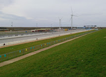
Still on the site of the old airbase we come to Santa Pod Raceway.The airfield was finally broken up in 1961 and sold to private investors.
However before all the airfield was ground into aggregate, a group of drag-racing enthusiasts approached the owners to use the main runway as a drag racing strip. In 1964 an agreement was reached for what became 'Santa Pod'. In 1972 the concrete was re-surfaced with asphalt and a major European centre for Drag Racing was created. The straight track is used for 1/4 and 1/8 mile racing.
Santa Pod is the venue at which the current world drag racing record, a time of 3.58 seconds at 386.26 mph (621.61 km/h) was set in July 1984. Santa Pod for many years remained the fastest all-asphalt drag-strip in the world since most North American tracks are partially or entirely concrete in construction.
 |
As you might imagine, it is extremely open and the wind has got up and become a bit chilly. We continue on the footpath going past Great Hayes Wood on our left. We are going in the direction of the railway line. Having been through a wind farm we are now surrounded by solar panels. Something we see more and more of while out walking. They do seem to be a missed opportunity to utilise better for wild life or wild flowers.
 |
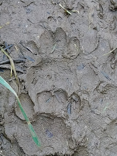
| Badger Paw print |
 |
| Little bridge over a stream |
Our path veers to the left and we are heading towards the village of Podington. The map shows that we are passing by a 'motte and Baileys'. Some kind of mound and structure, usually a castle or fortification of some kind.There is a lot of evidence of Badgers, some big setts on the banks. There are also some very distinguished 'Badger runs' in the fields. They probably make the same trip every night and create their own well worn paths.
Podington is a small picturesque rural village; many of its buildings are stone cottages dating from the 18th century, and some even earlier. It has a nice garden centre too. We weave through the village and pick up the path that will take us to the rural hamlet of Farndish. The name Farndish means fern-clad pasture. It is home now to Saxby's Cider Farm since 2011.Many of the apples are grown in their own orchards.The family used to have a business selling pork pies The business traded for over 100 years but sadly closed in 2008. I recall always having a Saxby's pork pie in the fridge at the weekend as I was growing up. They still keep the pig logo as a memento to those days which is a nice nod to the past. No cider today though unfortunately and onwards we go. It has now started to rain as approach the last and bleakest part of the walk. An uphill climb all the way across fields to the B569 and past the school, back to the start point in Wollaston. A cracking little walk, coming in at just over 11 miles.


If you're trying to decide on a realtor in Brampton, this link could make it easier: https://www.dhesirealestate.ca/
ReplyDeletebrampton-homes.ca has become one of my go-to sites for checking Brampton listings. Everything is organized really well.
ReplyDelete