Good to be back on the 'Shakespeare's Avon Way' footpath once again. Starting point is exactly where we left off last time in the lovely village of Clay Coton. Conditions are much better too! Last time we were here the road was flooded and the fields were a muddy nightmare.
Quite a short walk today as the footpaths are a bit limited for a circular walk. Probably fair to say that expectations are not altogether high. However sometimes it is the ones that you least suspect that throw up the most interest.
The footpath leads us past the wonderful former Church of St Andrew that ceased services in the 1950's. It then became derelict and was even threatened with demolition. It stayed fenced off for around 30 years all boarded up. Rescue finally came in the early 2000's when it was converted to a private home.
 |
| Former Church of St Andrew |
The Church is a 14th Century building much restored by the Victorians. The nave was rebuilt in 1866 but the west tower and the short spire are original.
Sadly much of the medieval wooden carvings were stolen during the years of abandonment.

Further on we find a dead lamb that has probably perished in the overnight cold weather. It is stamped with the number 13 which has proved unlucky for this poor creature....
 |
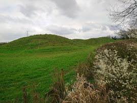
| Motte and Bailey |

Just outside of Lilbourne we get our first glimpse of the River Avon. We have walked past the local church, All Saints, which is Grade I listed building dating from the 12th century.
There are also the remains of a Norman 'motte and bailey' castle.(A fortification with a wooden or stone keep situated on a raised area of ground called a motte, accompanied by a walled courtyard, or bailey, surrounded by a protective ditch. It is always a moment of excitement to come across one of these.Windsor Castle in England, is an example of a motte-and-bailey castle.We pick up the next footpath that takes us uphill to the village of Catthorpe.
Catthorpe gives its name to the nearby Catthorpe Interchange road junction formed by the M1 and M6 motorways and the A14 road. So it can get pretty noisy around these parts.If we had carried on we would have ended up on the M6 so we detour across a large field. The field is only notable for the remains of a tree in the centre. There are numerous rabbit warrens that look pretty active judging by the amount of droppings around the base. Also a lot of the bark has been removed, possibly a Badger or Deer?
The path leads downhill to Catthorpe Manor, there seems to be an outdoor wedding venue within the grounds too. Down towards the pond we make a sad discovery by one of the trees. On closer inspection it transpires that it is Red Kite. It is perfectly intact with no signs of injury. Even the eyes have not yet been pecked out by the local crows. Hopefully it hasn't been poisoned and maybe died of hunger or the cold? I am starting to feel a bit like the 'Grim Reaper' today with all the death references....
 |
| Red Kite |
 |
It's a sad sight to see this most majestic of birds cut down in its prime. It is the first time that I have had the privilege of seeing a Red Kite at such close quarters and they really are a special bird of prey.
Thankfully following a reintroduction projects Red Kites are no longer endangered and are now a regular sight , particularly around Northamptonshire.
We leave the grounds of the Manor and pass under the motorway bridge. Following the footpath that then takes us alongside the A14.
Despite the busy road networks there is still an amazing abundance of wildlife, meadows, streams and open spaces. The path gradually pulls away from the A14 and we are heading back towards Clay Coton.
The church at our starting point comes into view and we are almost back. It really has been a cracking walk, not what we were expecting at all.
In total a total distance of 7.16 miles.
 |
 |


No comments:
Post a Comment